- v50 information can now be added to pages in the main namespace. v0.47 information can still be found in the DF2014 namespace. See here for more details on the new versioning policy.
- Use this page to report any issues related to the migration.
40d:Site map
The site map or location map is one of the possible modes in the Adventurer mode.
General Information
The site map is the most detailed mode available. In other words, its tiles do not represent a larger number of tiles in another map, even though an individual tile may contain several objects and/or creatures stacked on top of one another.
The exact size of the tiles is not defined and the flexible physics of the game make it difficult to pin any size down. However, it should be noted that each chair, table, bed, or other item of furniture requires a single tile for itself in order to be placed correctly.
While the adventurer explores the game in site map mode, they will over time grow thirsty and hungry.
Screen Structure
Central Area
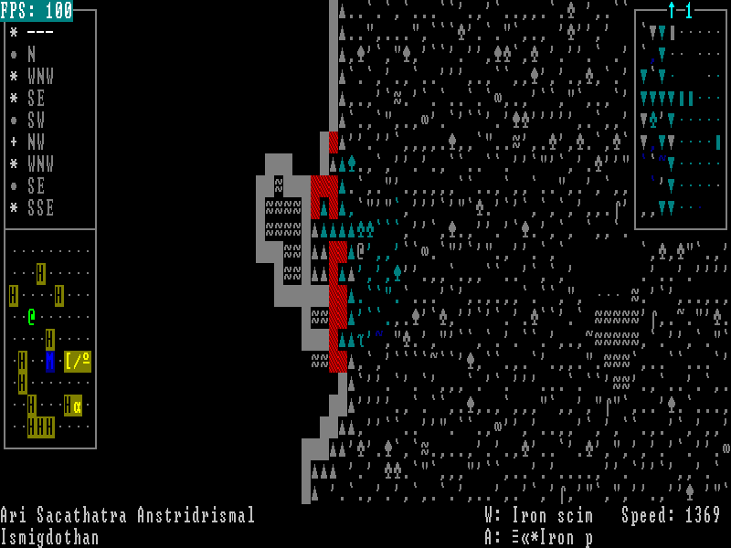
The central area of the screen shows the player character and the surrounding area.
Depending on the lighting, not the entire area may be visible. During the night or inside caverns, only a limited area is currently visible. In addition, obstacles like trees or walls will also impede visiblity.
Tiles which are unknown and currently invisible will be completely black. Tiles which have been seen before (either during the current visit to the area or during a previous visit), will show their usual character, but will be greyed out. If there had been a creature on a tile when the character last saw the tile, that is, the last turn the tile was visible, the creature's symbol will be shown in black on a purple background. It will remain there, until the tile becomes visible again.
Message Line
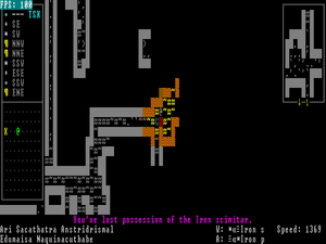
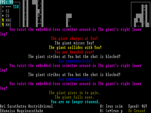
At the bottom of the site map, there is the message line where messages will be displayed, deducing one line from the central area. Usually, it is a single line. However, in certain situations where many things happen simultaneously, as in combat, it may turn into several lines covering parts of the screen.
You can clear it by pressing the space key.
Bottom Line Information
The two bottom lines contain several pieces of information.
On the first line on the left hand side, the character name will be displayed.
On the second line on the left hand side, the current location will be displayed. If the character is inside a named building, that building's name will be displayed. When inside a town or other location, that location's name will be displayed and only if none of these applies will the name of the region (that is, the local region the current travel map tile belongs to) be chosen.
On the first line, in the center, 'W:' is followed by the name of the current weapon.
On the second line, in the center, 'A:' is followed by the name of the current torso armor.
On the first line, on the right hand side, 'Speed:' shows the speed value of the character. The higher the value, the faster the character moves and acts and the basic value for humans is 1,000.
Upper Left
The upper left corner of the screen features a site compass. It lists the nearby sites of interests closest to the location you are currently at.
Each line lists one site, starting with the site you are currently at.
The first item in each line is the symbol for the site as seen on the travel map.
This is then followed either by compass directions or a line of white minusses '---'.
The '---' mean that the player character is currently at the specified location.
If a compass direction is shown, it refers to the direction in which the site is as seen from the player character's current tile. Compass directions can be simple, like 'N', but can also be more extensive like 'WSW', so they are fairly accurate. The color of the compass direction indicates how far the character is away from the site. Light green means is the closest beyond being at a location. Brown means nearby and dark grey indicates any distance beyond that.
There is one special appliance for the compass: If you are currently on a quest and have reached the quest location on the travel map, the compass on the site map will not show the white '---' until you have reached the precise quest location, like for instance the actual entrance to a cave. Instead, you will have light green compass directions pointing the way towards the quest location. Note that this is only the cave entrance or such. The location of a quest opponent is not given by the compass and needs to be figured through searching the quest location.
There is one more item a line may contain. That is a cyan 'TSK' marking a quest destination location. A character is on a quest for the entire time from accepting the quest until reporting the success to the quest giver. While the quest is not fulfilled yet (i.e. the quest monster has not been slain yet), the site of the quest (where the quest monster resides) will be marked with the 'TSK'. Once the quest has been fulfilled (i.e. the quest monster has been slain), the 'TSK' is moved to the town where the quest giver resides. Only once the quest is ended by reporting the success to the quest giver will the 'TSK' be removed completely.
Lower Left
The lower left area may contain a mini map if it is available.
The minimap is only available if you are in a town or when you are directly at a special/quest location, like for instance inside a cave. The minimap is not available on normal terrain maps or on cave location site maps themselves (that is the site map where the entrance to the cave is located).
In caves, the minimap currently seems to mark only the player character position as a light green '@' (![]() ) and the position of the cave entrance as a yellow 'X'. It does not show tunnels or creatures or any other features, so it basically only helps with basic orientation.
) and the position of the cave entrance as a yellow 'X'. It does not show tunnels or creatures or any other features, so it basically only helps with basic orientation.
In towns, the minimap shows the buildings you have either heard about or visited as well as the position of your character. Other creatures or features are not shown on the map and z-level differences are also not shown.
- In the town map, your own character is again the light green '@' (
 ).
). - A black 'H' on a brown background (
 ) marks housing, be it hovels or appartment buildings.
 - A cyan 'M' on blue (
 ) marks the town hall where the mayor can be found.
 - A grey rectangle of 2x2 tiles size with a white 'T' on a red background in the upper left corner (
 ) marks a temple.
 - A grey rectangle of 3x3 tiles size with a cyan 'K' on a blue background in the middle (
 ) marks a keep.
 - Yellow icons on a brown background depict stores:
Right Side
On the right hand side, neighboring z-levels may be shown.
Their displayal works basically like that of the central area as far as visibility is concerned.
These visuals only pop up once the character moves within range of an area where the character can either see onto a different z-level or where the character has previously seen the different z-level (the latter is very common during cave explorations where the surface z-level may show up on the right hand side).
These displays are framed and in the middle of the bottom or top frame, an arrow and a number will indicate the relative depth: A downward arrow in the bottom frame indicates that the z-level displayed is lower than where the character is currently located, while an upward arrow in the top frame indicates that the z-level is above the character. The number next to the arrow indicates the number of levels difference. So, seeing down a single-level slope would result in a down arrow next to the number '1', while seeing the roof of a 2-story building would generate an up arrow and the number '2'. In addition, arrow and number are light blue when displaying a z-level above the character's current position and brown when the extra z-level is below.
If there is a creature visible in the extra-display, the frame will be yellow.
Game Play Function
While the travel map allows for quick travel between locations, the site map is actually the location of the main interaction of the game. As such, you can only view your inventory while in site map mode. In addition, creature encounters also only take place on site maps; if you come across a creature while travelling, you will have to switch into site map mode (by pressing '>') - if it is not a random encounter, in which case you will automatically be forced into site map mode.
As was noted above, the character will grow hungry and thirsty while on a site map. However, site maps are the only location where you actually can obtain food and water as the travel map does not offer interaction with any game objects.
Time passes more slowly than on the travel map, but it is subject to day and night, as well as weather effects like rain.
In towns, the site map allows you to explore the town and speak with the inhabitants (using 'k'). This way you can gather information for your legends registry, also learn about nearby sites and their inhabitants, get quests from the mayor, and trade for better equipment or food.
When facing special sites like caves or goblin towers, the site map effectively resembles the normal gameplay of a rogue-like.


