- v50 information can now be added to pages in the main namespace. v0.47 information can still be found in the DF2014 namespace. See here for more details on the new versioning policy.
- Use this page to report any issues related to the migration.
Difference between revisions of "v0.31:Waterfall"
(Guess what, I edited the page.) |
|||
| Line 1: | Line 1: | ||
{{av}} | {{av}} | ||
{{Quality|Exceptional}} | {{Quality|Exceptional}} | ||
| + | |||
| + | ==General characteristics== | ||
A waterfall is any point on a {{L|river}} where water descends z-levels. | A waterfall is any point on a {{L|river}} where water descends z-levels. | ||
| − | ==Benefits of waterfalls== | + | ===Benefits of waterfalls=== |
| − | Waterfalls generate {{L|mist}}, which gives dwarves happy | + | * Waterfalls generate {{L|mist}}, which gives {{l|dwarf|dwarves}} happy {{l|thought}}s. |
| + | ** Consider building a path under your waterfall with {{L|floor grate}}s directly under your waterfall and building a {{L|activity zone|meeting area}} or {{L|dining hall}} behind the waterfall. This will result in a nice, constant shower of positive emotions for your dwarves as they waddle through the glorious mist. This also provides a nice constant shower to rinse your dwarves clean of {{L|blood}}, {{L|vomit}}, and {{L|mud}}, which may {{L|syndrome|save the fortress from a plague someday}}. | ||
| − | ==Drawbacks of waterfalls== | + | ===Drawbacks of waterfalls=== |
| − | Waterfalls will hamper your {{L|framerate}}. | + | * Waterfalls will hamper your {{L|framerate}}. |
| − | Waterfalls also have {{L|fun|interesting}} {{L|flood|effects}} on {{L|water pressure}}. Depending on what you are {{L|trap design|trying to do}}, this may actually count as a benefit. | + | * Waterfalls also have {{L|fun|interesting}} {{L|flood|effects}} on {{L|water pressure}}. |
| + | ** Depending on what you are {{L|trap design|trying to do}}, this may actually count as a benefit. | ||
==Locating a waterfall== | ==Locating a waterfall== | ||
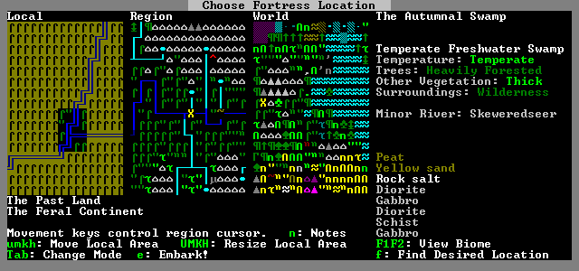
| − | While the site finder does not include waterfalls, the {{L|embark}} screen can still be used with fair accuracy to locate waterfalls for your fortress. Press {{k|Tab}} until you reach the relative height and cliff indicator screens, and follow rivers. Waterfalls are often located where two rivers intersect and the smaller river empties into the larger one. Some particularly tangled segments of rivers can result in maps with two or more waterfalls. Here, an example of a stream flowing into a minor river is shown. | + | While the site finder does not include waterfalls, the {{L|embark}} screen can still be used with fair accuracy to locate waterfalls for your fortress. Press {{k|Tab}} until you reach the relative height and cliff indicator screens, and follow rivers. Waterfalls are often located where two rivers intersect and the smaller river empties into the larger one. Some particularly tangled segments of rivers can result in maps with two or more waterfalls. Here, an example of a {{l|stream}} flowing into a minor river is shown. |
| + | |||
| + | |||
| + | <center>[[File:WaterfallLocation_2.png]]</center> | ||
| + | |||
| + | |||
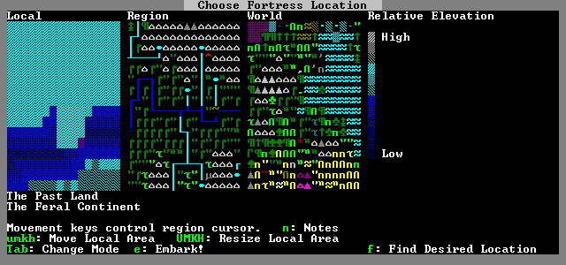
| + | In most {{L|region}}s the relative height of rivers will be the same. This is generally the darkest color, to indicate the lowest point. However, there are places where the relative heights along rivers will change. This is a good hint as to the presence of a waterfall. Generally, the greater the difference in color, the more impressive the waterfall will be. This is of course only a relative measure: the same difference in color implies wildly greater levels of scenic grandeur in {{l|mountain}}s than it does in {{l|flatland}}s. | ||
| + | |||
| − | [[File: | + | <center>[[File:Waterfall_3.png]]</center> |
| − | |||
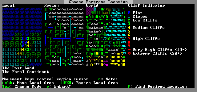
| − | + | The {{l|cliff}} indicator tool can be used to further confirm the presence of waterfalls, and to fine tune your embark area. In this example, the embark area straddles the tiles labeled as having cliffs with a height of four. The "flat" tiles labeled as dark blue zeroes are the southern extension of the stream: for the purposes of the {{l|site finder}}, all segments of the {{l|stream}} are on the same height, including the cliff at the end. The exact location of the waterfall will be in the zero sandwiched between the fours. You can use this knowledge to fine-tune your {{l|embark}} area to your favorite size. In this case, a 3x3 map could be centered on the bottom zero tile, and a fortress built around the majestic centerpiece. | |
| − | |||
| − | [[File:WaterfallLocation_1.png]] | + | <center>[[File:WaterfallLocation_1.png]]</center> |
| + | |||
| + | |||
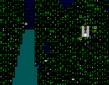
| + | Here is the end result of the example waterfall search: seven {{l|dwarf|dwarves}} milling around in the dirt, and the stream Bristleditches the Messianic Vomit falling five z-levels as it spills into the minor river Skeweredseer, a teeming source of {{l|alligator}}s, {{l|longnose gar}}, and {{l|carp}}. | ||
| − | |||
| − | [[File:WaterfallLocation_4.png]] | + | <center>[[File:WaterfallLocation_4.png]]</center> |
| + | |||
| + | |||
{{World}} | {{World}} | ||
[[Category:World]] | [[Category:World]] | ||
Revision as of 21:06, 22 May 2010
| This article is about an older version of DF. |
General characteristics
A waterfall is any point on a Template:L where water descends z-levels.
Benefits of waterfalls
- Waterfalls generate Template:L, which gives Template:L happy Template:Ls.
- Consider building a path under your waterfall with Template:Ls directly under your waterfall and building a Template:L or Template:L behind the waterfall. This will result in a nice, constant shower of positive emotions for your dwarves as they waddle through the glorious mist. This also provides a nice constant shower to rinse your dwarves clean of Template:L, Template:L, and Template:L, which may Template:L.
Drawbacks of waterfalls
- Waterfalls will hamper your Template:L.
- Waterfalls also have Template:L Template:L on Template:L.
- Depending on what you are Template:L, this may actually count as a benefit.
Locating a waterfall
While the site finder does not include waterfalls, the Template:L screen can still be used with fair accuracy to locate waterfalls for your fortress. Press Tab until you reach the relative height and cliff indicator screens, and follow rivers. Waterfalls are often located where two rivers intersect and the smaller river empties into the larger one. Some particularly tangled segments of rivers can result in maps with two or more waterfalls. Here, an example of a Template:L flowing into a minor river is shown.

In most Template:Ls the relative height of rivers will be the same. This is generally the darkest color, to indicate the lowest point. However, there are places where the relative heights along rivers will change. This is a good hint as to the presence of a waterfall. Generally, the greater the difference in color, the more impressive the waterfall will be. This is of course only a relative measure: the same difference in color implies wildly greater levels of scenic grandeur in Template:Ls than it does in Template:Ls.

The Template:L indicator tool can be used to further confirm the presence of waterfalls, and to fine tune your embark area. In this example, the embark area straddles the tiles labeled as having cliffs with a height of four. The "flat" tiles labeled as dark blue zeroes are the southern extension of the stream: for the purposes of the Template:L, all segments of the Template:L are on the same height, including the cliff at the end. The exact location of the waterfall will be in the zero sandwiched between the fours. You can use this knowledge to fine-tune your Template:L area to your favorite size. In this case, a 3x3 map could be centered on the bottom zero tile, and a fortress built around the majestic centerpiece.

Here is the end result of the example waterfall search: seven Template:L milling around in the dirt, and the stream Bristleditches the Messianic Vomit falling five z-levels as it spills into the minor river Skeweredseer, a teeming source of Template:Ls, Template:L, and Template:L.

Worlds | |
|---|---|