- v50 information can now be added to pages in the main namespace. v0.47 information can still be found in the DF2014 namespace. See here for more details on the new versioning policy.
- Use this page to report any issues related to the migration.
Difference between revisions of "v0.34:Legends"
(→Export Map/Gen Information.: Removed period) |
(→Legends viewing tools and visualisers: added reference to Satellite Map Maker) |
||
| Line 93: | Line 93: | ||
The most famous is likely [[Utilities#Legends_Viewer|Legends Viewer]], an alternative interface that recreates legends mode from exported data with many more features such as graphs, filtering, sorting, and hyperlinks. There are alternative tools with similar functionality, including World Viewer and an [https://github.com/crayZsaaron/df-legends-reader in-progress cross platform version] based on Python. | The most famous is likely [[Utilities#Legends_Viewer|Legends Viewer]], an alternative interface that recreates legends mode from exported data with many more features such as graphs, filtering, sorting, and hyperlinks. There are alternative tools with similar functionality, including World Viewer and an [https://github.com/crayZsaaron/df-legends-reader in-progress cross platform version] based on Python. | ||
| − | [http://www.bay12forums.com/smf/index.php?topic=73095.msg2261106#msg2261106 The Dwarf Map Maker | + | [http://www.bay12forums.com/smf/index.php?topic=73095.msg2261106#msg2261106 The Dwarf Map Maker] is available as a GIMP script (free software) or a photoshop actionscript. Both use the detailed maps to produce a pretty fantasy map. The GIMP script is called as part of PeridexisErrant's legends processing script, if the dependencies are present. Another GIMP script based on the previous one is [http://dffd.wimbli.com/file.php?id=8472 Satellite Map Maker] which produces a similar map that looks closer to satellite map imagery. |
{{Category|Guides}} | {{Category|Guides}} | ||
Revision as of 00:55, 30 December 2014
| This article is about an older version of DF. |
Legends mode is one of the three main methods of interacting with an already generated world. You cannot start Legends mode (or Fortress or Adventurer mode) until you create a new world.
Legends mode allows you to inspect the history of a world. Many players choose to design a world where the option Reveal all history is set to YES. However, if you set the option to NO, then the vast majority of the world's history will be hidden from Legends mode, and only uncovered by brave adventurers. In fact, there are many ways for an adventurer to uncover the past. Talk to people in civilized sites and they will tell you of their families, surroundings and local histories. Past events can also be found by viewing coins or items with images, or by visiting abandoned fortresses and viewing the engraved tiles within.
You don't have to have an adventure or fortress game active in order to use legend mode. Some players simply enjoy Legends mode for the option of looking at the interactive historical map, or to read about the last time their favorite kingdom went to war, or for the ability to export lists of all the sites and governments active in the world.
Legends information
Number of Events Undiscovered
A self-explanatory number indicating how many "legends" are still lost in the mists of time. If you chose to reveal all history during world generation, the number displayed should be 0. Otherwise, better get out there and adventure some more.
Historical Figures
The number to the right indicates how many historical figures exist in this world's history. Historical figures include entries on megabeasts, forgotten beasts, demons, gods, dwarves, humans, goblins, kobolds, and named creatures.
Sites
The number to the right indicates how many sites have existed throughout this world's history. Sites include things like towns, towers, fortresses, forest retreats, and caves.
Regions
A list of the various regions of the world, along with the various historical events that occurred within those regions.
Civilizations and Entities
The number to the right indicates how many civilizations, local governments, and religions have existed throughout this world's history. The histories of these various groups can be viewed as well, detailing events like when a site was founded, when a person was kidnapped, or when a road was completed.
Structures
Structures are buildings found throughout the world. Fortress, towers, shops, taverns, temples and more can all be found in this list. Temples are the central location of religions, and can be 'profaned' by historical figures, though it is not explained what this involves.
Historical Map
The historical map is a relatively new and very cool feature of Legends mode. From here you can view the territorial disputes between different civilizations and entities, including those who were destroyed before your starting year. If you are new to Dwarf Fortress, reading the map may be a little difficult, but play around with these buttons and you might get a better grasp of what you are seeing. Press Enter while looking at the map to change between the political and geographical view of the world. The geographic map is colored (blue seas, gray mountains, green forests etc.) while the political map's background is tan (think parchment) with colored fields corresponding to the territories of different civilizations. Civilizations can lay claim to the same area, causing the colored territory markers to overlap. You can also see how territories changes over time by moving 10 or 100 years forward and back through time. Pressing c while looking at the political map will show local government territories instead of civilizations, but that's generally a pretty messy scene.
The Age of...
During world generation, the Ages are named for the greatest powers extant in the world. Ages commonly advance during world generation (e.g. Age of Legends, Age of Heroes, Age of Humans) due to the death of megabeasts, and they sometimes even regress due to the creation of night creatures and the birth of new megabeasts. When you choose to look at the history of an Age, you will be given a list of all historical events in chronological order. Here you can read the battle reports from various wars, or the duels that took place between long dead champions, or the burninations rampages of megabeasts amongst the peasants. See here for a list of ages and their conditions.
Exporting information from Legends Mode
Legends mode has built-in tools to export lists of events, maps at various scales, and data such as locations of sites. This is particularly useful as input data for the utilities described below; there are even tools to make this export process easier.
XML dump
Once you've generated a world, you can dump much of the historical data into an XML file for external analysis. The XML dump currently doesn't include every detail of world history but it contains many of the important ones. Be warned that a large world with a thousand years of history can produce an XML dump up to a full gigabyte in size, which may prove unwieldy. Press x while in Legends mode to produce an XML dump (it will be placed in the root Dwarf Fortress directory and named the same as your game's save folder) See XML dump for information on the XML file's format.
Export Map/Gen Information
Another option is to export the map/gen information by pressing p in Legends mode. This produces three .txt files and one bitmap image that are placed in the root directory of Dwarf Fortress, named after the save file you're viewing:
- (save name)-world_gen_param.txt - contains the world generation settings.
- (save name)-world_history.txt - Includes some information about the deities, and rulers of the Human, Dwarven, Elven, and Goblin civilizations.
- (save name)-world_sites_and_pops.txt - Lists the sites' population, owner, parent civilization and warlord. This one will also list all the animal populations above and below ground including demons.
- world_map-(save name)-(year)--(some numbers).bmp - This is the full world map as it is shown on the embark screen, and unlike the detailed maps below will depend on the tileset and colour scheme you have installed.
Export Detailed Maps
Pressing d in Legends mode reveals a list of the different kinds map you can export. The Images are exported to the root directory when you highlight the one you want and pressing Enter.
- Standard biome+site map
- Elevations incl. lake and ocean floors
- Elevations respecting water level
- Temperature
- Rainfall
- Drainage
- Savagery
- Volcanism
- Current vegetation
- Evil
- Salinity
Legends Utilities
There are many utilities that work with the data exported from Legends mode, or made exporting that info easier.
Export tools
The dfhack script 'exportmaps' will export all detailed maps, saving a lot of time on large worlds compared to exporting them individually and waiting for each to finish. exportlegends likewise exports all detailed maps, as well as their worldgen info and legends XML.
Export processing script can automate processing of Legends information, and is included in the Windows Lazy Newb Pack. If GIMP is installed, the script will use Dwarf Map Maker (see below); optipng can be used to compress the images from bitmaps to .png files. This tool also removes non-printing ASCII characters from the XML dump that can crash Legends Viewer (usually caused by DFHack's workflow), and creates a compressed folder for each region suitable for Legends Viewer (or simply compresses the XML if some parts have not been exported).
Legends viewing tools and visualisers
The most famous is likely Legends Viewer, an alternative interface that recreates legends mode from exported data with many more features such as graphs, filtering, sorting, and hyperlinks. There are alternative tools with similar functionality, including World Viewer and an in-progress cross platform version based on Python.
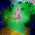
The Dwarf Map Maker is available as a GIMP script (free software) or a photoshop actionscript. Both use the detailed maps to produce a pretty fantasy map. The GIMP script is called as part of PeridexisErrant's legends processing script, if the dependencies are present. Another GIMP script based on the previous one is Satellite Map Maker which produces a similar map that looks closer to satellite map imagery.
